
About Land & Carbon Lab
What We Do

Measure & Monitor
We use the best data, science, and technology available to monitor all the world’s land and its nature-based carbon — publicly, independently, and in extraordinary detail. We track all forms of land cover, land use, and land use change globally, plus the associated carbon stocks and flows. Learn more.

Generate Insights
We analyze geospatial data to generate independent insights about the changing state of the world’s land, and how land is contributing to climate, biodiversity, and development goals. Our analyses inform policy design and foster accountability by showing where and why collective efforts are succeeding or failing to achieve international climate targets and commitments. Learn more.

Create Impact
We collaborate to turn complex geospatial data into actionable information to inform strategies, policies, investments, and on-the-ground actions that advance sustainable land management and create resilient landscapes. Our information serves decision makers who influence land use and land management outcomes at all scales — from corporate leaders and policymakers to Indigenous Peoples and farmers. Learn more.
What We Are Building
We are partnering with leading scientists and technologists to build and deploy comprehensive global land monitoring solutions that will create unprecedented transparency about what is happening to the world’s land anywhere on the planet, at any time.
A Global Monitoring System
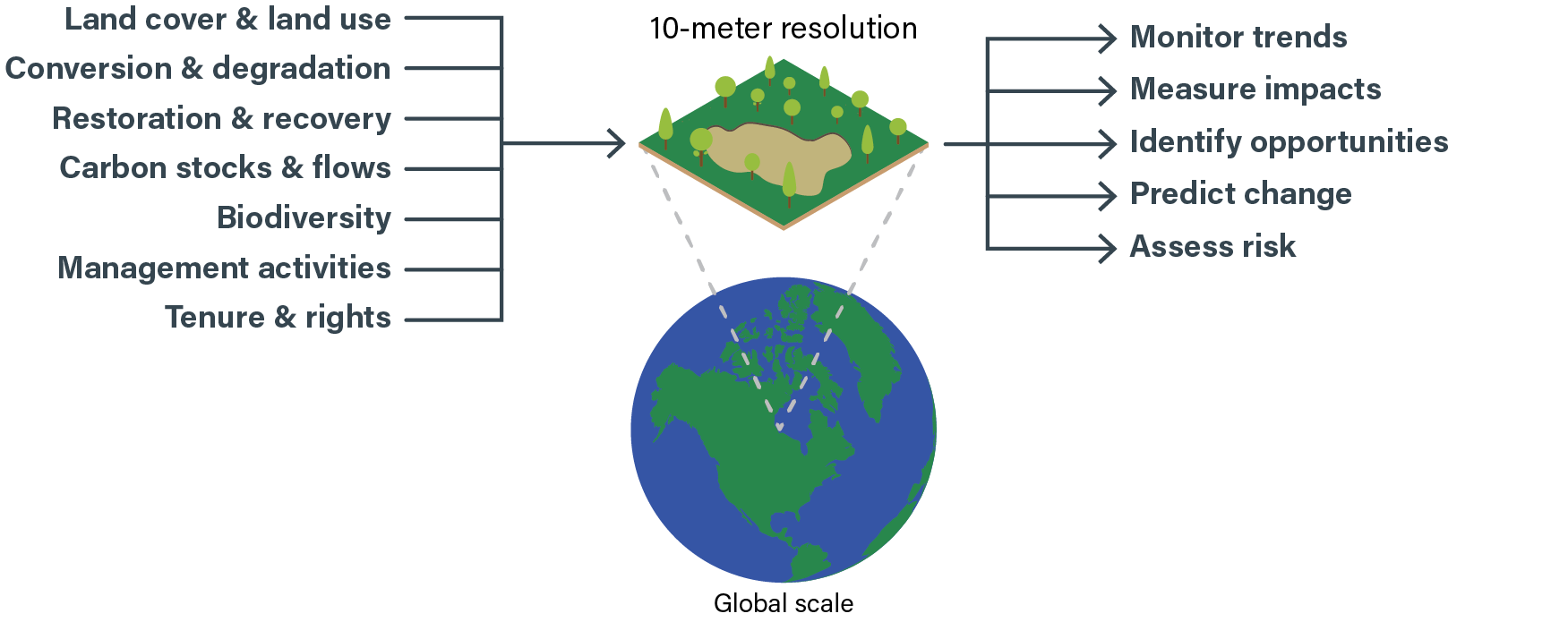
We are synthesizing troves of high-resolution geospatial datasets derived from satellites and other sources to classify every parcel of land on Earth according to its land cover and use — ranging from natural forests, grasslands, and wetlands to agricultural lands, agroforestry, and built-up environments.
This data will be updated annually and, for some, even more frequently, providing consistent global measurement of land use transitions over time.
We will monitor and alert users in near-real-time to ecosystem conversion and degradation, while also tracking restoration and recovery. We will integrate other high-resolution data on biodiversity, ecosystem services, tenure and rights, and management activities to shed light on the drivers and impacts of these land transitions. Critically, we will illuminate the climate implications of land use and land use change by monitoring carbon stocks, emissions, removals, and net fluxes at 30-meter resolution worldwide.
Our work builds and expands on Global Forest Watch, which provides high-resolution monitoring of the world’s forests. Our data is freely available via Resource Watch and its API.
Who We Are
Land & Carbon Lab is an initiative of World Resources Institute funded by our partner the Bezos Earth Fund. We work with diverse partners, connecting those at the vanguard of land monitoring with those at the frontlines of land use decisions. Together, we can transform data into impact.
Anchor Funder

Founding Partners


Funders